


 MENU
MENUBlog by Brayden McNeill, BASc, MSc – Technical Sales and Marketing Lead at Aquanty Inc.
For the longest time I associated Tecplot 360 with computational fluid dynamics for the aerospace and automotive engineering industries. It wasn’t until I joined Aquanty that I learned how useful Tecplot 360 can be in the environmental and water resources engineering sector!
Hi, my name is Brayden McNeill and I’m the technical sales and marketing lead at Aquanty. We’re a Waterloo, ON based water resources science and technology firm specializing in predictive analytics, simulation and forecasting, research services, and IoT, founded in 2012 by the key developers of HydroGeoSphere.
What is HydroGeoSphere (HGS)?
HydroGeoSphere (HGS) is the world’s most powerful hydrologic modelling package. As a fully-integrated hydrologic modelling engine, HGS is able to handle all aspects of the terrestrial flow of water. That means it can handle 2-dimensional surface water flow, 3-dimensional variably saturated groundwater flow, flow through discrete fracture networks, tunnels, channels, tile drains, evapotranspiration and more!
By integrating various components such as precipitation, surface water, groundwater, and water quality into a unified model, we gain a more holistic understanding of the intricate interactions within a watershed. This comprehensive insight allows for better-informed decision-making and management strategies. In addition, HGS is able to handle a variety of additional processes which are dependent on hydrologic conditions such as solute transport, geothermal energy transport, landfill leachate modelling, aquifer storage and recovery and managed aquifer recharge scenario analyses, saltwater intrusion studies, mine water management, real-time hydrologic forecasting, climate change impact analyses and much more.
Tecplot 360 for In-Depth Analysis
The overall utility of these models is limited by the visualization and analysis tools that we can apply to the models, which is why we rely on Tecplot 360 for post-processing of simulation outputs. The large number of processes built into the fabric of HydroGeoSphere simulations means that these models are typically orders of magnitude more complex than similar groundwater or surface water only models. Tecplot 360’s ability to easily handle a wide variety of data inputs is a key requirement for us, as we can effectively visualize both groundwater and surface water flows simultaneously. The ability to extract data at key points of interest, visualize time-series charts and link various data frames together allows us to achieve a deeper insight into the hydrologic system.
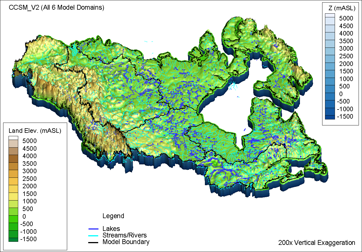
Canada1Water– Basin Scale Models Across Continental Canada
Another major benefit that Tecplot 360 brings to the table is its ability to process incredibly large datasets with ease! While it isn’t exactly a super-fancy or visually appealing capability, the simple fact that Tecplot 360 is able to visualize and manipulate hundreds of millions of datapoints without crashing a run-of-the-mill desktop computer is really impressive. The advanced data management capabilities offered by Tecplot 360 have kept pace with our ever ambitious modelling goals, allowing us to build simulations at larger and larger scales. For example, Aquanty is currently working on a first-of-its kind project called Canada1Water – the first ever climate change impact analysis of integrated hydrology at the continental scale.
If you’re interested in learning more about how we use Tecplot 360 in our day to day consulting operations at Aquanty, watch our recent webinar – Visualizing HydroGeoSphere Results using Tecplot 360.